A more active severe weather pattern is getting underway in the Midwest and Plains, which could produce large hail, wind damage and a strong tornado threat into early next week
By Chris Dolce, Jonathan Belles, and Jonathan Erdman
Strong Tornadoes, Damaging Winds, Hail Possible
A multiday siege of severe weather will first strike the Great Lakes and Midwest through the end of this week before shifting to the Great Plains over the weekend and into early next week.
Tornadoes – some possibly strong – damaging hail and destructive straight-line winds are all potential threats in what could be multiple outbreaks of severe thunderstorms through Tuesday.
The Latest
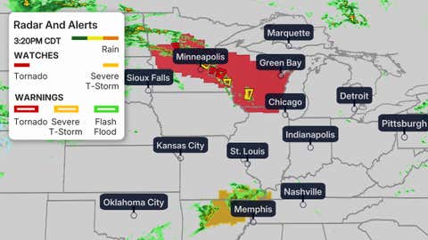
The map below shows the latest radar, watches and warnings issued by NOAA’s Storm Prediction Center and the National Weather Service.
There have already been at least a couple of confirmed, brief tornadoes in Swift County, Minnesota, Thursday near Benson and Danvers. Reports of a rotating wall cloud, sometimes the precursor of a tornado, prompted a tornado warning earlier this afternoon for downtown Minneapolis and some of the city’s northern suburbs, where pea-size hail was reported in the far northwest suburb of Rogers.

Current Radar, Watches, Warnings
Late Week Forecast
-Through Thursday Night: Areas shaded in red below from east-central Minnesota to much of Wisconsin, northeast Illinois, northern Indiana, western Michigan and northwest Ohio have the greatest chance to see severe weather in the late afternoon and evening hours, including Chicago and Milwaukee. Hail the size of golf balls or larger, damaging straight-line winds and a few tornadoes, possibly strong (EF2 or greater damage), are possible in this area.
The chance of severe weather will be more isolated in areas farther south toward the Ohio Valley, as shaded in orange. But, any severe storms that form in this area could pack high winds, damaging hail and a tornado threat.
Isolated severe storms could also extend as far east as the mid-Atlantic.
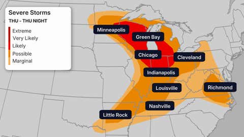
Thursday’s Severe Weather Forecast
(This shows the likelihood of severe thunderstorms, according to NOAA’s Storm Prediction Center.)
-Friday-Friday Night: An outbreak of severe storms is possible in the Ohio and mid-Mississippi valleys, as shaded in the red areas below. That includes Cincinnati, Indianapolis, Louisville, Kentucky, Nashville and St. Louis.
Damaging hail larger than the size of golf balls, high winds gusting over 75 mph and tornadoes are all potential threats. Some tornadoes could be strong.
Widespread damaging winds capable of downing many trees and knocking out power will be a particular concern from southeast Missouri to southern Illinois, southern Indiana and western and central Kentucky.
Other more isolated severe storms could extend as far southwest as the Ark-La-Tex, and as far northeast as the mid-Atlantic.
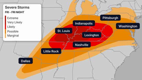
(This shows the likelihood of severe thunderstorms, according to NOAA’s Storm Prediction Center.)
Weekend-Early Next Week Forecast
-Saturday: Scattered severe storms could impact the mid-Atlantic and the South.
-Sunday-Monday: The biggest threat of severe storms will shift into the Central and Southern Plains, particularly from Kansas into Oklahoma and northern Texas. While it’s too early for specifics, the storms could bring a tornado threat as well as wind damage and large hail.
Dallas-Fort Worth, Oklahoma City and Tulsa, Oklahoma, and Wichita, Kansas, are a few of the cities that should keep a close eye on the forecast for Sunday and Monday.
-Tuesday: Severe weather may shift farther east toward the Ark-La-Tex and mid-Mississippi Valley.
Check back to The Weather Channel App and weather.com for updates on this forecast through the next several days and we’ll provide more information.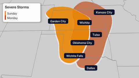
(The areas shaded above show where there is the highest confidence in severe weather occurring Sunday and Monday, according to NOAA’s Storm Prediction Center. This forecast is subject to change in future updates.)
A More Favorable Pattern For Severe Weather
A pair of southward plunges of the jet stream will carve into the West, then spread toward the central states. One will arrive later this week, followed by another this weekend into early next week.
In this pattern, warm and humid air eventually streams north from the Gulf into the Plains and Midwest under that active jet stream.
It’s a setup more favorable for severe thunderstorms this time of year in the Plains and Midwest, which are the regions where tornadoes are most common in May.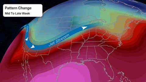
Chris Dolce has been a senior digital meteorologist with weather.com for nearly 15 years after beginning his career with The Weather Channel in the early 2000s.